_______________________________________________________________________________________________________
SOUTHERN CALIFORNIA SURF FORECAST UPDATED on 10-15-18
_______________________________________________________________________________________________________
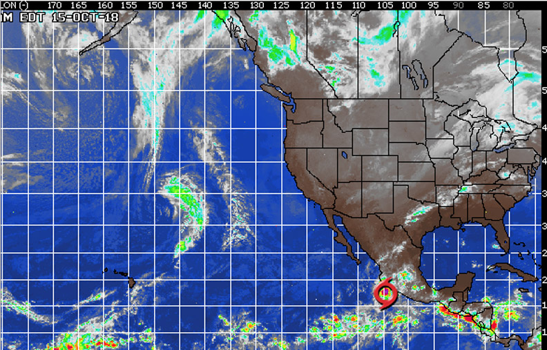
HURRICANE WATCH
Tropical Depression 22 strengthened this morning into Tropical Storm Tara about 100 miles off the coast of Mexico. Although Tara is expected to remain offshore, it will be close enough to land to bring heavy rainfall to the Mexican states of Michoacan, Colima and Jalisco over the next day or two. This rain can lead to flash flooding and mudslides, especially in the mountains.
_______________________________________________________________________________________________________
For Monday morning smallish SW swell will be the only show in town with waist to chest high sets for the better South facing breaks.
Monday
2018-10-15 Mon 04:35 AM 3.46 feet High Tide
2018-10-15 Mon 06:59 AM Sunrise
2018-10-15 Mon 07:31 AM 3.33 feet Low Tide
2018-10-15 Mon 01:11 PM Moonrise
2018-10-15 Mon 01:57 PM 4.45 feet High Tide
2018-10-15 Mon 06:19 PM Sunset
2018-10-15 Mon 10:15 PM 1.05 feet Low Tide
2018-10-15 Mon 11:30 PM Moonset
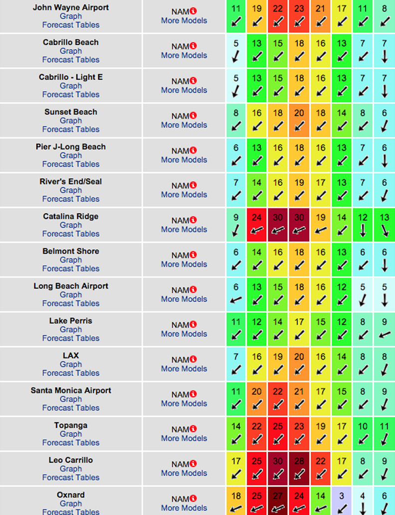
The conditions look great with offshore Santa Ana breezes out of the E/NE/NNE all day long. The air temp tops skyrockets to 78 degrees.

______________________________________________________________________________________________________
For Tuesday morning we’ll see continued waist to chest high sets for the better South facing breaks, (from 215-220 degrees and 15-15 second intervals), in the AM and that will taper off throughout the day. Right on its heels will be another SW ground swell from 215 degrees and 16-17 second intervals
Tuesday
2018-10-16 Tue 06:16 AM 3.73 feet High Tide
2018-10-16 Tue 07:00 AM Sunrise
2018-10-16 Tue 10:08 AM 3.44 feet Low Tide
2018-10-16 Tue 11:02 AM First Quarter
2018-10-16 Tue 01:57 PM Moonrise
2018-10-16 Tue 03:36 PM 4.22 feet High Tide
2018-10-16 Tue 06:18 PM Sunset
2018-10-16 Tue 11:27 PM 0.98 feet Low Tide
The conditions look good again with continued Santa Ana winds and breezes out of the NE/NE at 4-14 MPH until noon, (stronger below passes and canyons), and 5-9 MPH out of the SW in the afternoon. The air temp tops out at a toasty 78 degrees.
______________________________________________________________________________________________________
For Wednesday morning we’ll see continued waist to chest high sets out of the SW for the best South facing breaks. The angle is 215-220 degrees with 14-15 second intervals.
Wednesday
2018-10-17 Wed 12:21 AM Moonset
2018-10-17 Wed 06:54 AM 4.02 feet High Tide
2018-10-17 Wed 07:00 AM Sunrise
2018-10-17 Wed 11:51 AM 3.14 feet Low Tide
2018-10-17 Wed 02:40 PM Moonrise
2018-10-17 Wed 05:07 PM 4.26 feet High Tide
2018-10-17 Wed 06:17 PM Sunset
The conditions look pretty good again with Easterly breezes at 1-5 MPH until noon, (stronger below passes and canyons), and 6-9 MPH out of the West in the afternoon. The air temp dips to 76 degrees.
______________________________________________________________________________________________________
For Thursday morning we’ll see continued sets out of the SW, (215-220 degrees at 14-16 seconds), that should deliver continued waist to chest high sets at the better South facing breaks.
We’re also expecting to see some fresh NW ground swell comes down the line from 300-310 degrees with stout 15-16 second intervals. That energy should put the better exposed West facing beaches into the chest high + zone.
Thursday
2018-10-18 Thu 12:20 AM 0.85 feet Low Tide
2018-10-18 Thu 01:15 AM Moonset
2018-10-18 Thu 07:01 AM Sunrise
2018-10-18 Thu 07:19 AM 4.27 feet High Tide
2018-10-18 Thu 12:42 PM 2.71 feet Low Tide
2018-10-18 Thu 03:18 PM Moonrise
2018-10-18 Thu 06:11 PM 4.45 feet High Tide
2018-10-18 Thu 06:16 PM Sunset
The conditions look pretty good again with variable breezes at out of the N/NE/NNE at 1-5 MPH until noon and SW at 6-10 MPH in the afternoon. The air temp tops out at 75 degrees.
______________________________________________________________________________________________________
For Friday morning that NW energy should hold and dish up chest high + sets from that same angle of 300-310 degrees and 14 second intervals.
Also in the mix will be some remnant SW energy. Likely sporadic waist high + sets at the exposed breaks.
Friday
2018-10-19 Fri 12:59 AM 0.74 feet Low Tide
2018-10-19 Fri 02:09 AM Moonset
2018-10-19 Fri 07:02 AM Sunrise
2018-10-19 Fri 07:40 AM 4.52 feet High Tide
2018-10-19 Fri 01:18 PM 2.25 feet Low Tide
2018-10-19 Fri 03:54 PM Moonrise
2018-10-19 Fri 06:14 PM Sunset
2018-10-19 Fri 06:59 PM 4.65 feet High Tide
The conditions look pretty good again with N/NNE breezes at 1-5 MPH until noon and 5-10 MPH out of the SW in the afternoon. The air temp tops out at 78 degrees.
______________________________________________________________________________________________________
Water temps are as follows, (day of 4CAST update) and are as follows: Malibu 65, Santa Monica 65 South Bay 67, Huntington 63, Newport 64.
______________________________________________________________________________________________________
The next 4CAST will be posted on Sunday!
______________________________________________________________________________________________________
ABOUT THE SWELLMAGNET FORECAST – One of the most exciting–and yet most challenging–aspects of surfing is the sheer variety of waves and weather conditions that affect the entire surfing experience. Any surfer who is interested in going beyond the most basic level of surfing will have to develop the ability to interpret waves and environmental conditions. This is important for ensuring both a safe and enjoyable experience.
The main difficulty lies in predicting how exactly the ocean and the environment will behave at any given time. One day, you could be riding four-footers all day and the next, you might be facing a glasslike surface with nary a ripple. Conditions can change drastically from day-to-day and even within the space of a couple of hours. To avoid wasted time and unproductive trips to the surf, it is essential to have access to reliable information on surf conditions.
Sites such as Swellmagnet.com offer up-to-the-minute surf reports that are essential to all California surfers. The company relies on an extensive network of surf cams and surf experts in order to monitor the precise surf conditions on any given day. All information is collated and analyzed by qualified surf specialists, with the resulting data being provided to the public via the Swellmagnet site.
Swellmagnet provides some of the best surf reports in the industry, with accurate and verifiable results gathered via an innovative system of surf condition monitors and detectors. Expert surf analysis is provided by the company’s team of highly experienced specialists, each with long years of experience monitoring and actually experiencing the full range of surf conditions. This combination of state-of-the-art technology and extensive practical experience ensures the highest quality and most accurate surf reports available.
For surfers who wish to take full advantage of the best that the California coast has to offer, the services provided by Swellmagnet are essential.

